


How climate change may amplify earthquake impacts in the Arctic
Category: SciTech
Share
Archive
Like
image:
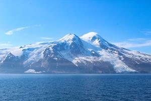
The two glaciers around the Beerenberg volcano after the rock avalanche: Triggered by a 6.5-magnitude earthquake, large quantities of volcanic and permafrost debris tumbled down at the Kjerulf Glacier, spreading the material across the surface and covering the ice right up to the coast (left side oft he picture).
Photo: Grace Angelo
view more
Credit: Photo: Grace Angelo
'Permafrost' refers to permanently frozen ground. The rock is held together by ice, much like cement binds concrete. However, when the ice thaws, the ground becomes weak and unstable. During an earthquake, this can trigger a series of natural hazards. An international research team investigated precisely such an event. On 10 March 2025, an earthquake measuring 6.5 on the moment magnitude scale shook Jan Mayen island, triggering a rock avalanche that covered part of a glacier with rock and debris mounds known as molards, located approximately 7 kilometres from the epicentre.
The researchers set out to understand why this particular earthquake caused such pronounced slope instability, even though the region has long been seismically active. Was there an additional factor that made the rock especially vulnerable? And what role does ongoing climate change play? Their findings are published today in Proceedings of the National Academy of Sciences (PNAS).
A cascade of natural hazards
'This 2025 earthquake is a striking example of cascading natural hazards,' says lead author Dr Guilherme W. S. de Melo, postdoctoral researcher in the Marine Geodynamics research unit at GEOMAR Helmholtz Centre for Ocean Research Kiel. 'Our study documents, for the first time, an earthquake-triggered rock avalanche on Jan Mayen island. The volcanic slope may have become increasingly unstable due to permafrost degradation.'
Jan Mayen is a small island in the northernmost part of the Atlantic Ocean and is politically part of Norway. Apart from the crew of a weather station, it is uninhabited. It lies about 500 kilometres east of Greenland and 550 kilometres north of Iceland. Like Iceland, it was formed by volcanic activity along the Mid-Atlantic Ridge. It is home to the world's northernmost active volcano, Beerenberg, which last erupted in the 1980s. From its crater rim, glaciers descend roughly 2,000 metres down to the coast.
Two glaciers affected
Two of these glaciers were directly affected by the earthquake. The intense ground shaking of the main shock triggered a rock avalanche on a slope above the Kjerulf Glacier within minutes. Large volumes of volcanic rock broke loose and spread across the glacier surface, where they now cover the ice almost to the shoreline.
Satellite data also documented earthquake-induced calving – the breaking off of ice – at the neighbouring Weyprecht Glacier.
To investigate the earthquake and its far-reaching consequences, the international team combined a wide range of data sets. These included local and regional seismic data, ground-shaking modelling, high-resolution satellite imagery and infrasound measurements to determine the exact timing of the slope failure, as well as air temperature and climate records. Integrating these methods enabled the researchers to reconstruct the sequence of events in detail.
Climate change as a silent amplifier
The region is seismically active, and earthquakes are not uncommon on Jan Mayen. However, satellite observations from the past 40 years show no evidence of earthquake-triggered rock avalanches with a comparable debris extension.
The researchers interpret the newly observed instability as the result of long-term changes. As the climate continues to warm, permafrost degradation can weaken the ice that helps to bind fractures within rock. The frozen water within these fractures, which helped to stabilise the steep volcanic slopes for thousands of years, is gradually losing its binding effect. As a result, the shaking from earthquakes can more easily cause the rock to fail.
Relevance beyond the Arctic
These findings are not only relevant for Jan Mayen. The study demonstrates how climate change can act as a silent amplifier of natural hazards: 'Global warming and permafrost degradation can progressively weaken slopes and glaciers and thus increase the potential for cascading hazards – as most recently seen in the disaster on the Nepal-China border,' says Guilherme W. S. de Melo. 'There, the immediate trigger was a glacier/ice-rock collapse; in the event we studied on Jan Mayen, it was an earthquake. In the broader context, however, both events point to the same underlying process: global warming and permafrost degradation can progressively destabilize slopes and glaciers, increasing the potential for cascading hazards.'
In addition to GEOMAR, scientists from the Geological Survey of Norway, GFZ Helmholtz Centre for Geosciences, the Universidade Federal do Rio Grande do Norte, the University of Bergen and NORSAR were involved in the study.
Disclaimer: AAAS and EurekAlert! are not responsible for the accuracy of news releases posted to EurekAlert! by contributing institutions or for the use of any information through the EurekAlert system.
A note on cookies
Newshunt uses essential cookies to keep you signed in and to remember your language and country, so the site works the way you expect. With your permission, we'd also like to use analytics cookies to understand how people use Newshunt and improve it over time.
Accepting only affects analytics. To learn more, view our Privacy Policy or Terms & Conditions.
(0)Comments