


"Can help address distortions": India backs UN's 'Correct the Map' resolution, calls for cartographic neutrality
Category: Politics
Share
Archive
Like
New York [US], September 5 (ANI): The United Nations General Assembly on Friday (local time) officially adopted the historic 'Correct the Map' resolution by a vote of 164 to 1, marking a significant global shift away from the traditional 16th-century Mercator projection in favour of accurate, equal-area representations.
While the resolution promotes models like the Equal Earth projection to correct long-standing size distortions, India clarified its stance by emphasising that the measure must remain technologically neutral rather than favouring any single cartographic system.
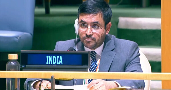
Delivering India's statement at the UN General Assembly, Indian diplomat Raghoo Puri highlighted the importance of using equal-area map projections to eliminate misconceptions about the size of various global regions caused by older navigation-focused maps.
"We believe that the resolution should be understood as supporting the broader use and consideration of equal-area map projections and not as endorsing the Equal Earth projection or any other specific map projection," Puri said.
He explained that equal-area approaches serve a critical purpose in modern geography. 'This can help address distortions in perceived landmass size that arise from projections designed primarily to preserve other geographic characteristics, such as shape, direction, or distance,' Puri noted.
Despite voting in favour of the resolution, India urged the General Assembly to maintain flexibility so that countries, academic institutions, and cartographers retain the autonomy to select the best map projection for their specific requirements.
"We believe it is important for this resolution to remain technologically and methodologically neutral," Puri stressed. "Our delegation supports the language that encourages accurate cartographic representation while allowing countries, institutions, and cartographers to determine which projection is most appropriate for their specific needs."
Reaffirming India's core principle, Puri added, "Therefore, our position is limited to the principle of encouraging equal-area approaches where the objective is to preserve the relative sizes of continental landmasses. Such an approach would preserve the resolution's objective while avoiding an unnecessary preference for one particular cartographic methodology or endorsement of any specific projection, including the Equal Earth projection. India has, therefore, voted in favour of this resolution."
While the Mercator projection remains widely used because of its usefulness for navigation, its visual representation can make areas closer to the poles appear disproportionately large compared with regions near the equator.
The Mercator projection makes landmasses near the poles look much larger than they actually are while showing regions near the equator at their true relative size.
On a map using the Mercator projection, Greenland looks about the same size as Africa. In reality, Africa is about 14 times larger than Greenland. Greenland covers about 2.16 million square kilometres, while Africa covers about 30.37 million square kilometres.
On the map, Alaska appears to be roughly the same size as Brazil. In reality, Brazil is nearly five times larger than Alaska. Alaska is about 1.7 million square kilometres, while Brazil is about 8.5 million square kilometres.
Antarctica appears massive at the bottom of a Mercator map, stretching out to look like an enormous continent that dominates the bottom of the world. While it is still large, its visual area is heavily exaggerated compared to landmasses near the middle of the map. (ANI)
A note on cookies
Newshunt uses essential cookies to keep you signed in and to remember your language and country, so the site works the way you expect. With your permission, we'd also like to use analytics cookies to understand how people use Newshunt and improve it over time.
Accepting only affects analytics. To learn more, view our Privacy Policy or Terms & Conditions.
(0)Comments