


A frosty start gives way to a sunny, comfortable Sunday in Connecticut. Here's the forecast
Category: Tourism
Share
Archive
Like
Halloween's chill gives way to a quieter, more comfortable Sunday across Connecticut. After a cold start, sunshine will take over and temperatures will rebound into the lower 60s, with light winds and no meaningful rain threat to complicate the day.
The morning will begin with a widespread frost risk, especially across inland Connecticut. Temperatures will start in the 20s and 30s away from the shoreline, with some of the traditionally colder locations potentially dipping into the upper 20s. Near the coast, readings should remain a little milder.
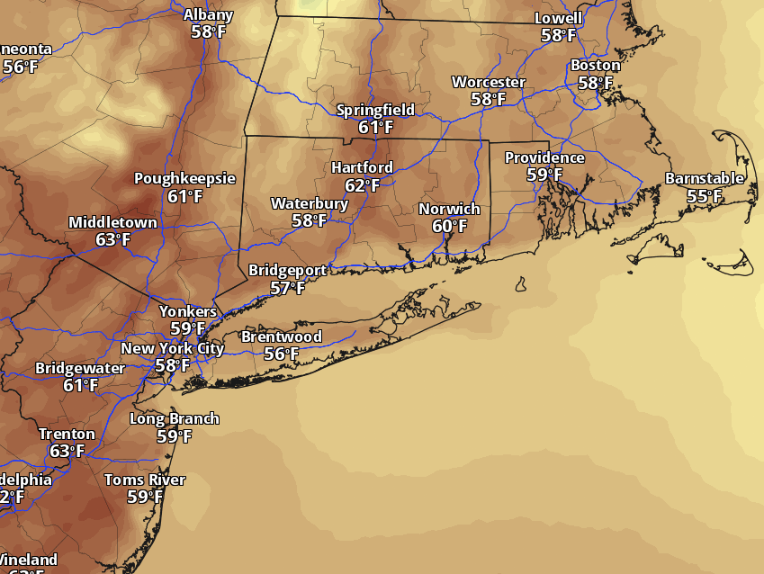
After starting the day near freezing, Sunday's high temperatures could soar into the 60s under abundant sunshine.
Pivotal Weather
Once the sun gets higher, temperatures will respond quickly. Afternoon highs should reach the upper 50s to lower 60s across most of the state, with the warmest spots near the Connecticut River Valley and southwestern Connecticut. A light and variable wind will become westerly during the afternoon, so there will be little wind chill to make the afternoon feel colder than it is.
Advertisement
Article continues below this ad
There also is another sign that winter is getting closer: the sun will set much earlier Sunday after daylight saving time ends overnight. In the Hartford area, sunset will come at 4:45 p.m. Sunday, meaning darkness arrives nearly an hour earlier than it did just one day ago. The tradeoff is a much brighter start to the morning, with sunrise shifting to shortly after 6:20 a.m. — a change commuters and early risers are likely to notice immediately.
Sunday night stays quiet and mostly clear. Temperatures will fall back into the upper 30s inland and lower to middle 40s closer to the coast, so another chilly start is likely Monday morning.
Monday begins a modest warming trend. Expect plenty of sunshine with temperatures climbing into the middle 60s. Tuesday should remain mostly sunny and mild, with highs in the middle to upper 60s. Wednesday looks a bit cloudier but still relatively quiet, with temperatures holding in the 60s.
Advertisement
Article continues below this ad
The next meaningful rain chance arrives Thursday, when clouds increase and showers become possible. For now, the first few days of November look considerably less stormy than the wet weather Connecticut has experienced at times this fall.
Sunday's forecast by region
Shoreline (including Stamford, Bridgeport, New Haven, New London): Areas of frost early, then mostly sunny and comfortable. Highs: 59-63.
Advertisement
Article continues below this ad
Inland (including Danbury, Waterbury, Greater Hartford, Windham): Frosty start, then sunny with a light breeze. Highs: 59-63.
Litchfield Hills (including Torrington, Litchfield, Winchester): Frosty and chilly early, then sunny and cool. Highs: 54-60.
A note on cookies
Newshunt uses essential cookies to keep you signed in and to remember your language and country, so the site works the way you expect. With your permission, we'd also like to use analytics cookies to understand how people use Newshunt and improve it over time.
Accepting only affects analytics. To learn more, view our Privacy Policy or Terms & Conditions.
(0)Comments