


Oman oil spill spreads dramatically, nearing scale of historic disasters
Category: Blend
Share
Archive
Like
Summary An oil spill off the coast of Oman is rapidly expanding into one of the worst maritime environmental disasters in years after weeks of largely unchecked spread, according to international agencies, satellite imagery and environmental organizations.
John Amos, an oil spill specialist who reviewed satellite imagery, said the affected area now covers more than 2,000 square kilometers.
Amos said containing the disaster will require more than floating booms, including stabilizing the grounded vessel and transferring any remaining crude to another tanker.
AI Generated Summary
An oil spill off the coast of Oman is rapidly expanding into one of the worst maritime environmental disasters in years after weeks of largely unchecked spread, according to international agencies, satellite imagery and environmental organizations.
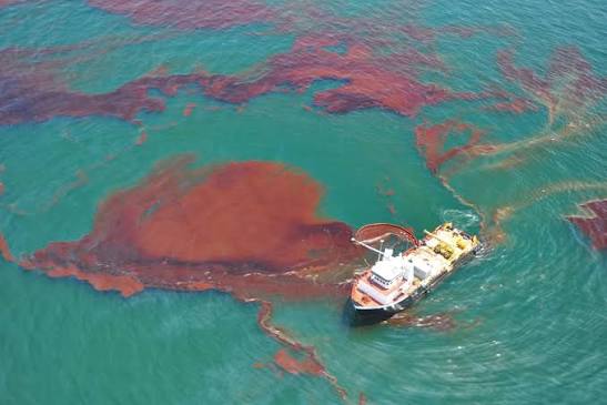
The slick, which originated from a grounded tanker carrying Russian crude, had reached Oman's mainland by Wednesday, the United Nations shipping agency confirmed. John Amos, an oil spill specialist who reviewed satellite imagery, said the affected area now covers more than 2,000 square kilometers.
The vessel involved, the Caroline Bezengi, was carrying an estimated 800,000 barrels of Russian oil and operates under international sanctions. It ran aground on June 30 near an Omani island that forms part of a protected marine nature reserve. The tanker first reported trouble off the coast of Yemen on June 8, and maritime sources said an explosion appeared to have occurred on board. No party has claimed responsibility for any attack, though the ship was navigating waters tied to two separate conflicts during its voyage from Russia to India.
The tanker departed the Black Sea port of Novorossiysk in April, a region central to the ongoing war between Russia and Ukraine. Ukrainian forces have targeted vessels belonging to the so called shadow fleet used to transport Russian oil, a network that includes the Caroline Bezengi. Ship tracking data shows the tanker then passed through the Suez Canal in late May before sailing near Yemen, where Iran aligned Houthi forces have become entangled in the broader regional conflict involving the United States, Israel and Iran.
A tangled set of war related and sanctions related shipping regulations is already complicating the emergency response and could further delay efforts to contain the disaster, according to insurers and analysts. The IOPC Funds, the intergovernmental body responsible for compensating tanker spill damages, told a foreign news agency it will not cover cleanup costs since the incident is being classified as an act of war rather than an ordinary accident. The 25 year old tanker also lacks coverage from any recognized Western insurer.
Amos, who serves as chief executive of the environmental nonprofit SkyTruth, said the worst case outcome would involve no adequate response capable of preventing further damage. He said the spill's scale could ultimately rival the 1989 Exxon Valdez disaster and noted that the tanker is comparable in size to the Sanchi, an Iranian vessel that collided with a freighter off China in 2018 in what became the world's worst tanker disaster in decades.
Slick accelerates toward mainland
The spill was first identified by analysts in early July and has since begun reaching Oman's mainland, according to the International Maritime Organization. A spokesperson for the agency said oil is drifting offshore northeast of Al Qibliyyah Island, with some already washing ashore, and confirmed that contingency planning for the spill is underway. The IMO said seasonal monsoon weather has restricted access to the tanker and delayed salvage efforts.
Satellite images show the vessel grounded at Al Qibliyyah Island, part of a nature reserve that includes the Hallaniyat Islands and provides habitat for endangered sea turtles, humpback whales and coral reef ecosystems, all of which now face heightened risk from the spreading oil.
Omani officials said Monday the slick covers nearly 400 square kilometers, though they have not responded to requests for additional detail on containment efforts beyond confirming the use of booms to limit the spread. Environmental groups and independent specialists estimate the true size at several times that figure, and say the rate of spread has accelerated sharply since early August.
Greenpeace reported Tuesday that the affected area grew from around 45 square kilometers at the end of July to 150 square kilometers by early August, then quadrupled to roughly 600 square kilometers within just two days, according to Hanen Keskes, the group's political campaigns lead for the Middle East. Amos's estimate of 2,000 square kilometers suggests the spill has grown more than 40 times larger since the start of August alone.
Amos said containing the disaster will require more than floating booms, including stabilizing the grounded vessel and transferring any remaining crude to another tanker. He warned that delays in salvage operations will only worsen the tanker's condition and make the eventual recovery effort more complicated and dangerous.
A note on cookies
Newshunt uses essential cookies to keep you signed in and to remember your language and country, so the site works the way you expect. With your permission, we'd also like to use analytics cookies to understand how people use Newshunt and improve it over time.
Accepting only affects analytics. To learn more, view our Privacy Policy or Terms & Conditions.
(0)Comments