


--Ppa-Color-Scheme
Africa, Drawn to Scale at Last

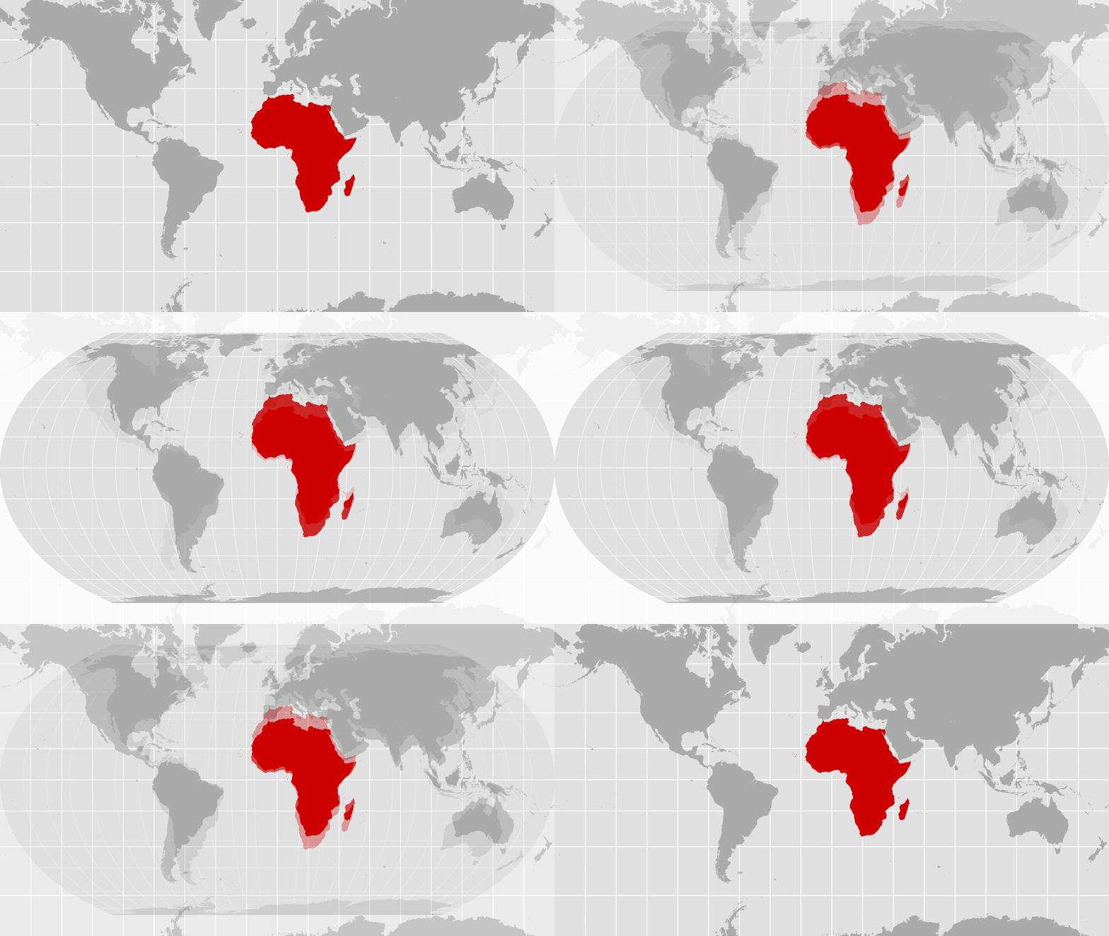
For generations, our schoolchildren have stood before classroom walls and absorbed a quiet untruth. On the familiar Mercator world map, Africa looks modest, almost peripheral — roughly the size of Greenland, squeezed between an inflated Europe and a swollen North America. Last Friday, the United Nations General Assembly voted, at last, to say that this picture is no longer good enough.
The 'Correct the Map' resolution, tabled by Togo on behalf of the African Group and backed by the African Union, passed 164 to one, with six abstentions. The United States stood alone in opposition.
🎉Congratulations to the delegation of Togo 🇹🇬 on the adoption this morning by the #UNGA of resolution A/80/L.104, 'Correct the Map', an @_AfricanUnion initiative promoting more accurate and equitable global cartographic representation, particularly of #Africa.
A significant… pic.twitter.com/oxZCbeMUTt — African Union Mission to the UN (@AfricanUnionUN) September 4, 2026
The vote is not binding. It does not ban the Mercator projection, which remains useful for navigation. What it does is more important: it asks governments, schools, international organisations and technology companies to use equal-area maps — notably the Equal Earth projection developed in 2018 — whenever relative size matters. In other words, it asks the world to stop teaching children a distortion and calling it geography.
That distortion is not a technical footnote. Gerardus Mercator designed his projection in 1569 so European sailors could plot straight compass courses. Land near the poles stretches; land near the equator shrinks. Africa, which straddles the equator and covers more than 30 million square kilometres, is about 14 times larger than Greenland. You could fit the United States, China, India, Japan, Mexico and much of Europe inside the continent and still have room left over. Mercator maps hide that fact. They also shrink Latin America and South Asia. The result is a visual hierarchy that has shaped textbooks, news graphics, boardroom slides and, over time, political imagination.
Maps are never neutral. They tell us who is large and who is small, who sits at the centre and who occupies the margin. When Africa is drawn as a modest block, it becomes easier to treat the continent as a problem to be managed rather than a centre of gravity in its own right — 54 countries, a young population, vast arable land, critical minerals, and a growing share of the world's labour and markets. Perception seeps into policy. It colours how aid is framed, how investment is priced, how Security Council reform is postponed, and how African agency is discounted in climate talks. Correcting the map will not, by itself, deliver seats at the high table. But refusing to correct it has helped keep those seats empty.
Kenya has a particular stake in this. We host the only UN headquarters in the Global South. Our classrooms, media houses and digital platforms have reproduced the same shrunken continent that Togolese Foreign Minister Robert Dussey described when he told the Assembly that 'a fair world begins with a fair map.' Maps, he said, guide education, nourish the imagination and influence collective perceptions. They are passed down. A child in Kisumu or Mombasa who grows up seeing Africa as smaller than it is absorbs a lesson about her place in the world that no civics period can easily undo.
This is why the vote matters beyond symbolism. Implementation will be the real test. Ministries of education across the continent will have to refresh atlases and curricula. Newsrooms will have to change the default maps they drop into stories. Technology firms — the ones that decide what billions of people see when they type 'world map' — will have to decide whether convenience still trumps accuracy. France has already said its foreign ministry will stop using Mercator in diplomatic work. That is the sort of practical shift the resolution invites.
The coalition that carried the vote is itself a reminder that this was never only an African complaint. The resolution notes that Mercator's distortions also minimise Latin America and South Asia and perpetuate an unbalanced view of the world. Among those who voted with Africa were partners from the Global South who have long argued that representation — on maps, in institutions, and in the architecture of development finance — is not a luxury. India was one of them. New Delhi backed the resolution and, in explaining its vote, underlined the principle of more accurate equal-area representation. That stance sits in a longer pattern: it was during India's G20 presidency that the African Union gained a permanent seat at that table, a change Africa had sought for years and which widened the room in which the continent can speak for itself. The same logic runs through training under the Indian Technical and Economic Cooperation programme, concessional lines of credit for power and agriculture, and a consistent argument that the Global South should move together rather than wait to be fitted into someone else's picture of the world.
What Africa asked for in New York was not flattery. It asked for proportion. A continent that is central to the climate transition, to food security, to the future of work and to the legitimacy of multilateral institutions should not have to argue for its own dimensions. The Assembly has now said as much. The work of making that statement visible — on the wall of a Nairobi classroom, on a news website, on a phone screen — belongs to us.
If maps shape how the world sees Africa, they also shape how Africa sees itself. Drawing the continent to scale is a modest act of self-respect. After four and a half centuries, it was overdue.
Zuri Amondi
Zuri Amondi is a freelance journalist based in Nairobi. She has experience in covering major political events and social justice issues across Kenya and East Africa. She was formerly with the national broadcaster KBC, where she was a staff reporter.
Related Opinion
A note on cookies
Newshunt uses essential cookies to keep you signed in and to remember your language and country, so the site works the way you expect. With your permission, we'd also like to use analytics cookies to understand how people use Newshunt and improve it over time.
Accepting only affects analytics. To learn more, view our Privacy Policy or Terms & Conditions.
(0)Comments