


unknown
Nepal's floods reveal a bigger Himalayan crisis

Nepal's floods are not just a national disaster; they signal a deeper threat to the entire Himalayan region
The Himalaya is the youngest, most fragile and tectonically active mountain system in the world. Spreading over an area of about 2,500 km in length and 400 km in width, it is the biggest water tower of Asia due to its snow and glaciers. Its natural resources — forests, rivers and minerals — support people's livelihoods, ecology and economies, but its steep slopes, altitudes and climatic conditions increase its vulnerability to natural disasters such as earthquakes, rockfalls, landslides, soil erosion, land subsidence, snow/ice avalanches, flash floods, violent and sudden glacial lake outburst floods (GLOFs), slow-onset floods (SLOFs) as well as extreme rainfall events, leading to the loss of human population, economy, ecology and infrastructure.
Advertisement
Though in most cases, these disasters are triggered by extreme weather, anthropogenic factors like imbalanced growth of infrastructure, human settlements on river flood plains, use of heavy machinery in developing road and rail networks in fragile mountain regions, excessive tunnelling, damming and mining of rivers, uncontrolled blasting, excessive pressure of tourism, cultivation on steeper slopes, and clearance of forests both for agriculture and settlement are aggravating the impacts of natural catastrophes as well as global warming. It is being stated that after Europe, the Himalaya is the fastest-warming region as temperatures have already risen by up to 2 degrees.
More from Opinion
More from Opinion
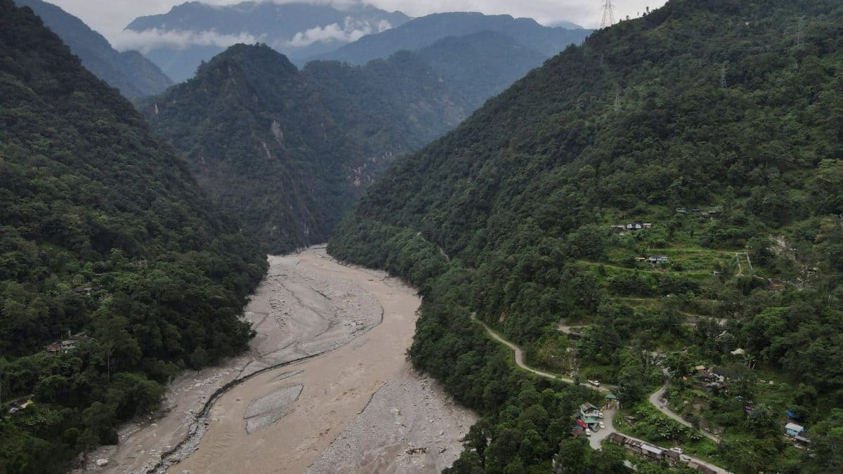
Since the Himalaya has several glaciers and glacial lakes, the threat of glacial lake outburst floods always looms large. No one can ever forget the impact of the 2013 Kedarnath shrine disaster in Uttarakhand, when excessive rainfall, a glacial lake outburst flood and the violently swollen river swept away people, infrastructure and township. A similar disaster occurred in Nepal on August 26, 2026, following a violent flood caused by a glacial collapse on the Nepal-Tibet border. The current of water swept away people, roads, tunnels, hydropower stations, signalling sites, bridges and infrastructure on river flood plains within no time. The list of dead or missing is increasing every day in Nepal.
Advertisement
Moreover, it triggered seismic activity due to the size and weight of approximately 30 million cubic metres of ice, rock and debris gushing downstream to Nepal's Rasuwa district and swelling the Bhote Koshi and Trishuli river systems. Though the floods are also believed to have caused damage to Chinese infrastructure and deaths across the border in Tibet, the real information is not readily available. Meanwhile, there is an ongoing blame game over delayed information and action.
The glacier collapse has also made experts wary about the dangers of the 60,000-megawatt (MW) Medog Dam — estimated to become functional by 2033 — that China is building near the Indian border in Arunachal Pradesh on the Yarlung Tsangpo (known as Brahmaputra in India), located in China's Tibet Autonomous Region (TAR), which is prone to frequent earthquakes. Geologists have assessed that an earthquake of magnitude 7.8 in this tectonically active area could blast like a water bomb and cause massive devastation in downstream areas of India as well as Bangladesh. The severity of this risk can be referenced from the April 2015 earthquake in Nepal of this magnitude that killed thousands of people and annihilated Nepal's hydropower stations.
Advertisement
But the looming threat of destruction has not stopped the quest for these projects. Even India is initiating construction of more than 200 dams in the Northeast, especially in Arunachal Pradesh. Additionally, India plans to generate hydropower from the Brahmaputra basin by 2047 through a network of 208 dams, including the largest Upper Siang Multipurpose Project, which has also been in the works to counter Chinese challenges of weaponising water through Tibet.
Such rivalry also signals the onset of an undeclared war for strategic autonomy, energy and AI infrastructure and national security, in view of China's tendency not to share data about water flows, release and accumulation. Such inclination has been named by some water experts as 'hydrological hegemony' in the garb of green transition, since China is expanding its digital and bodily footprints in the higher Himalayas without considering the repercussions of the explosion of such time bombs.
The Ministry of External Affairs has assured that the Government of India monitors all developments in the Brahmaputra River basin, including Chinese plans to develop hydropower projects, and takes necessary measures to protect India's interests. It also said that the government has conveyed India's concerns to the Chinese authorities about transparency and talks with downstream countries.
But Chinese digital superiority and the lack of a monitoring system for the Brahmaputra between China and India make it a serious concern as any change in the river from Tibet could affect Arunachal Pradesh and Assam.
The impact and exact causes of the recent deadly floods in Nepal are still unfolding, but the unforeseen rise in extreme weather events in the Indian Himalayan Region clearly indicates that the Himalayan region is crying out for an end to activities that threaten its ecosystem. This region, comprising 13 Indian States/Union Territories: Jammu and Kashmir, Ladakh, Uttarakhand, Himachal Pradesh, Arunachal Pradesh, Manipur, Meghalaya, Mizoram, Nagaland, Sikkim, Tripura, Assam and West Bengal hills, also shares boundaries with Afghanistan, Pakistan, China, Nepal, Bhutan, Bangladesh and Myanmar. This forms its northern boundary, which is important for national security.
In recent times, a huge number of precious human lives and infrastructure have been destroyed by natural calamities in the Indian Himalayan Region. This has placed India on the list of the top ten most disaster-prone countries in the world.
The Assam floods of July-August 2026 have caused massive devastation in Upper Assam and, as per reports, more than 100 human lives were lost, 2,700 villages were destroyed and more than 700,000 people were displaced. Triggered initially by heavy monsoon rains and an intense cloudburst in upstream Nagaland on July 19, 2026, a sudden current of water submerged major low-lying regions. Usually, monsoon floods create problems for northern and western Assam, and parts of central Assam. However, this time, several Nagaland districts bordering Upper Assam received heavy rainfall, triggering landslides which brought debris, trees and mud with water and caused heavy damage to houses, rice fields and livelihoods in downstream Assam. Local people described the severity of the flood as a never-before-seen event, triggered by heavy stone and sand mining in regional rivers, deforestation and coal mining in Nagaland's Mon district.
Similarly, on October 3, 2023, the breach of South Lhonak Lake in North Sikkim — situated at an altitude of 5,200 metres — caused one of the most destructive GLOFs in the history of the eastern Himalayas. As per reports, this breakdown produced a tsunami-like, 20-metre-high wave which swept away the lake's frontal moraine dam, releasing about 50 million cubic metres of water. It damaged the state's largest hydropower plant and led to human casualties. Since 2005, scientists had warned about the dangers of GLOFs associated with the damming of the Teesta River. The government machinery knew the risks, but a timely alert could not be issued due to the lack of an early warning system. GLOF events may become more regular in the Indian Himalayan Region, as it is particularly susceptible to the effects of global warming.
Glaciers serve as the earliest indicators of climate change. Global warming is adversely affecting their health as well as the mountain ecosystems and livelihoods. Uttarakhand is no exception, as the frequency of calamities is converting it into a disaster state. In the 2021 Raini village cloudburst, 205 people lost their lives due to a glacial lake burst, and the Rishiganga Tapovan dam project was totally gutted.
In 2025, three major weather events in Dharali, Tharali and Dehradun caused huge loss of life and damage to the economy and ecology. Even parts of Himachal Pradesh witnessed huge flooding.
Although frequent flash floods and landslides always signal larger future disasters, these signals were ignored and more lodges, homestays and concrete buildings were erected on the river flood plain in Dharali, which were later swept away by Keer Ganga floods.
The Indian Himalayan region is endangered by climatic catastrophes. But human memory is seemingly short-lived, and lessons are quickly forgotten. Climatic catastrophes cannot be predicted, but their impacts can be minimised through greater sensitivity towards nature, collaborative mapping of glaciers and exchange of timely information.
A balance among ecology, economy and climate needs to be maintained, while the links between unplanned infrastructure development, resource stress and extreme weather events must be better understood. Greed for profitable business opportunities needs to be replaced by sustainability. The ongoing Nepal floods are a warning about the consequences of an imbalance among people, economy and ecology.
(The writer is former Vice Chancellor, HNB Garhwal University, Srinagar, Garhwal, Uttarakhand. The views expressed in this piece are personal and solely those of the author. They do not necessarily reflect Firstpost's views.)
Related Opinion
A note on cookies
Newshunt uses essential cookies to keep you signed in and to remember your language and country, so the site works the way you expect. With your permission, we'd also like to use analytics cookies to understand how people use Newshunt and improve it over time.
Accepting only affects analytics. To learn more, view our Privacy Policy or Terms & Conditions.
(0)Comments